• Recent
  • Towns
  • Topics
    • Arts
      • Language
      • Museums & Galleries
      • Public Art
    • Civic Life
      • Citizen Engagement
      • Governance
      • Health & Well-Being
      • Refugees
    • Community Heart & Soul
    • Economic Development
      • Breweries & Distilleries
      • Entrepreneurs
      • Transportation
    • Education
      • K-12
      • Community Colleges & Technical Training
      • Colleges & Universities
    • Environment & Sustainability
      • Parks & Recreation
      • Trees
    • Local Institutions
      • Libraries
    • Local Journalism
    • Travel
      • Aviation
  • Homepage
  • About
  • Donate
  • Newsletter
  • Recent
  • Towns
  • Topics
    • Arts
      • Language
      • Museums & Galleries
      • Public Art
    • Civic Life
      • Citizen Engagement
      • Governance
      • Health & Well-Being
      • Refugees
    • Community Heart & Soul
    • Economic Development
      • Breweries & Distilleries
      • Entrepreneurs
      • Transportation
    • Education
      • K-12
      • Community Colleges & Technical Training
      • Colleges & Universities
    • Environment & Sustainability
      • Parks & Recreation
      • Trees
    • Local Institutions
      • Libraries
    • Local Journalism
    • Travel
      • Aviation
  • Homepage
  • About
  • Donate
  • Newsletter
  • Travel

There’s a Reason They Call It ‘Eastport’

East is east, and west is west, and the twain can meet—sort of.

  • James Fallows
  • February 16, 2014

Share

The Atlantic is all about the uplifting clash of contending ideas. Thus our current print issue — yes, subscribe! — carries a “correction” to my article in the January issue, about the beleaguered but plucky little town of Eastport, Maine:

I would like to correct a geographical inaccuracy: the easternmost point in the U.S. is not in Maine at all; it is in Alaska. The 180th meridian of longitude divides east from west and runs through the Aleutian Islands. So, in Alaska, one could stand facing north with one’s left foot on the easternmost point in the U.S. and one’s right foot on the westernmost. The dateline, however, zigzags, to keep political subdivisions in the same time zone. Thus, although Maine is not the easternmost place in the U.S., it sees the sun before Alaska on any given day.

John Godfrey
Beverly, Mass.

I know that a person as punctilious as this correspondent will be grateful for even further refinement of his point. Toward that end I offer this rejoinder just now from reader David Strip, of New Mexico.

While John Godfrey is correct that the point in the US with the easternmost longitude lies in Alaska, I find this irrelevant to the notion of finding the extreme point in a given direction.

Most reasonable people would find the easternmost point of a contiguous landmass by a process mathematically equivalent to drawing a line of longitude through the landmass and sweeping it in an easterly direction until it touches a single point. That would be the easternmost point.

The problem is slightly complicated when the country in not contiguous, though in that case I suspect most people would pick the starting point of their sweep to be either the center of mass of the country (if you’re mathematically inclined), or at some point inside the largest component of the country. The fact that Godfrey himself points out that the easternmost point lies to the west of the westernmost points out the absurdity of his claim.

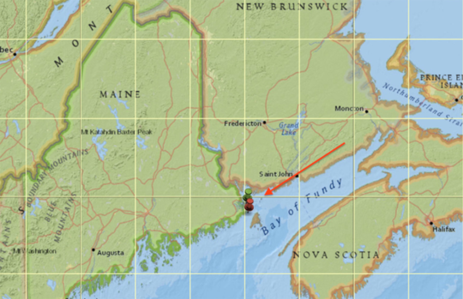
I am with Mr. Strip. If you start at any point in the United States and, contrary to the advice of Horace Greeley, keeping heading east, the coastal reaches of “Down East” Maine are where you’ll end up. And the only possible contender to Eastport as the place at which you could make no further progress east would be the neighboring town of Lubec, which is microscopically closer to the watery boundary with Canada. Eastport is in green below, Lubec in red.

A zillion miles to the west, we have the extremities of the Aleutians, where they are so far west that they switch from West to East longitude. Sensibly, the International Date Line swings out at this point to include those in the furthest-west time zone of the United States and for that matter of the world.

Emboldened by the date line, I’m sticking with Eastport for the easternmost crown.

Tweet
Share
Share
Share
Tags
  • From The Readers

Newsletter

For more from Our Towns, please sign up for our newsletter here.


Latest

  • Image of children playing around a water tower, with bright paintings on it and the message "You Have Found Lost Hills" 1
    Finding the City of Lost Hills
    • June 4, 2025
  • Library building on a sunny day in San Diego. 2
    How Libraries Are Becoming ‘Sustainable’
    • August 6, 2024
  • Children doing nature drawings, in antique photo. 3
    Sustainability: Suddenly the action is local.
    • May 9, 2024

Related Articles

View from the right seat of the Cirrus. Storms near Bowie, Arizona. (Deborah Fallows)
View Post
  • Travel

Summer in Our Towns

  • Deborah Fallows
  • August 7, 2023
The path a regional jet took this past Thursday, after taking off from Dulles airport outside Washington and then quickly returning, following a clockwise route. The plane is ID’d on this map as Delta 3857, and its passengers had Delta tickets. On air-traffic frequencies it is called “SkyWest 3857,” the name of the Delta feeder airline. (This image is a screenshot from the AirNav RadarBox site.)
View Post
  • Aviation

Cooperation, Calm, and Competence: This Is How It Sounds

  • James Fallows
  • February 1, 2022
View Post
  • Aviation

The Quiet Competence That Makes the Country Run

  • James Fallows
  • October 20, 2021

STAY CONNECTED

Receive the latest news and updates

SUBSCRIBE

© 2025 Our Towns Civic Foundation. All Rights Reserved.

  • Contact
  • Privacy Policy
  • Republishing Policy

Input your search keywords and press Enter.